
NEW YORK – The United Nations has overwhelmingly backed an African-led push for world maps that show the continent closer to its true relative size. The vote challenges a centuries-old projection that has shaped how generations see Africa, while leaving the United States alone in opposing the resolution.
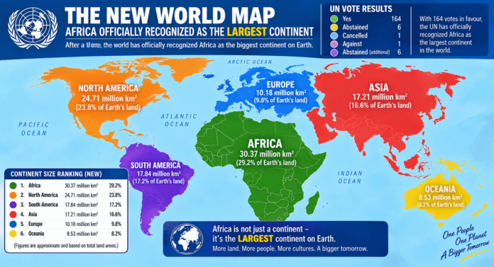
The UN General Assembly adopted the resolution on September 4 by 164 votes to one, with six countries abstaining. Togo introduced the measure on behalf of the African Group, with support from the African Union. The initiative calls for wider use of the Equal Earth projection instead of relying heavily on the traditional Mercator map.
At the heart of the debate is a distortion familiar to millions of people. Flemish cartographer Gerardus Mercator developed his projection in 1569 to help sailors navigate. It became one of the world’s most recognisable maps, but it greatly enlarges land masses closer to the poles. Countries and continents near the equator appear much smaller by comparison.
Africa provides one of the clearest examples of that distortion. The continent covers about 30.3 million square kilometres and is roughly 14 times larger than Greenland. Yet the Mercator projection can make Greenland and Africa appear far closer in size than they really are.
The distortion also enlarges Europe and North America in relation to Africa and South America. As a result, the familiar world map does not provide an accurate visual comparison of the continents.
The Equal Earth projection offers a different view. Cartographers developed it in 2018 to preserve the relative area of countries and continents more accurately while maintaining a familiar world-map shape. No flat map can perfectly represent a spherical planet, but equal-area projections provide a better comparison of physical size.
The UN resolution does not seek to ban Mercator, which remains valuable for navigation. Instead, it encourages governments, schools, international organisations and technology companies to use Equal Earth or other equal-area projections when relative size matters. It also calls for greater awareness of the limitations of conventional world maps.
African campaigners argue that the issue extends beyond geography. Maps are among the first visual tools children use to understand their place in the world. When Africa repeatedly appears smaller than its true scale, campaigners say that image can influence perceptions of the continent’s importance and relationship with other regions.
The United States cast the only vote against the resolution and strongly criticised the initiative. Washington described it as part of a “radical ideological project” and argued that the debate diverted attention from more urgent international challenges.
Estonia, Georgia, Lithuania, Moldova, Serbia and Ukraine abstained, while 164 countries supported the African-led proposal. The scale of the vote gave the initiative overwhelming international backing despite US opposition.
Washington’s position also turned what could have remained a technical debate about cartography into a wider geopolitical story. African governments have increasingly challenged international systems and conventions that they argue fail to represent the continent fairly.
France has signalled support for changing its official mapping practices, while Togo plans to update educational materials. Supporters also want technology companies and other major map providers to consider wider use of equal-area projections.
The campaign does not claim that Mercator deliberately set out to diminish Africa. Its original purpose was navigation, not the comparison of land area. The concern centres instead on how a specialised navigation tool became a standard representation of the world in classrooms, offices and public spaces.
The physical scale of Africa helps explain why the campaign has gained attention. The continent is large enough to contain the United States, China, India and substantial parts of Europe within its land area. Conventional maps rarely communicate that scale clearly.
That makes the debate about more than replacing one projection with another. It raises questions about how inherited systems shape global perceptions and why standards created centuries ago can continue influencing how people understand the modern world.
African institutions have become more assertive in challenging those conventions. The map campaign fits a wider effort to strengthen African agency in global institutions and reshape narratives about the continent.
The UN vote now gives that campaign greater diplomatic weight. General Assembly resolutions of this kind do not force governments or companies to change their maps, but overwhelming international support can influence education, public policy and institutional practice.
A shift towards equal-area projections could eventually change what children see on classroom walls and what organisations use when comparing continents. Digital platforms could also play an important role because millions of people now encounter world maps through phones, computers and online services.
Changing a map cannot alter Africa’s borders, population or economic power. It can, however, change the visual starting point from which people understand the continent.
More than four centuries after Mercator created a map for sailors, African governments are asking the world to reconsider whether it should still define how people see the relative size of the planet. With 164 countries supporting that argument, the question has moved from cartography into a wider conversation about representation, perception and Africa’s place in the world.